Table of Contents >> Show >> Hide
- A Lost Colony Reappears in the Brazilian Amazon
- Why This Discovery Matters More Than a Good Treasure Story
- The Forest Was Never Empty
- How Lidar Turned the Jungle Transparent
- Colonial Power, Forced Labor, and the Human Cost of Frontier Building
- The Bigger Amazon Story: Cities, Roads, and Garden Urbanism
- Why Archaeologists Are Racing the Clock
- What This Discovery Changes
- Experiences That Bring the Story to Life
- Conclusion
- SEO Tags
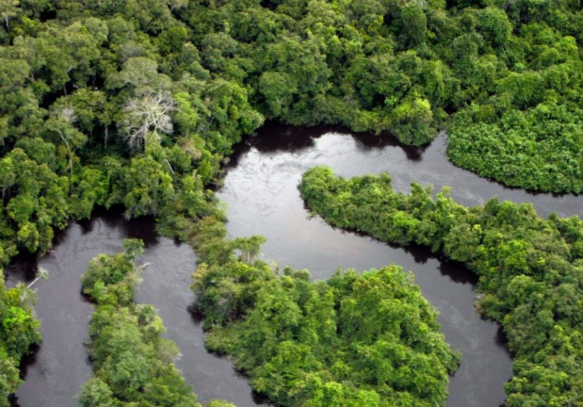
The Amazon has a reputation for being dramatic, and frankly, it has earned it. It can hide a river wider than some countries, grow a forest canopy thick enough to turn noon into late afternoon, and apparently tuck away a colonial settlement for centuries like it misplaced its keys. Now archaeologists using lidar, a laser-based mapping technology that can “see” through dense vegetation, have helped bring that missing history back into view. What they found was not just a few scattered stones in the mud, but the outline of an 18th-century Portuguese colony in Brazil’s Amazonroads, canals, fortifications, and traces of a settlement long thought swallowed by the jungle.
That headline-worthy discovery is exciting on its own, but the real story is even bigger. This is not simply a tale of one lost town making a surprise comeback. It is part of a growing body of research showing that the Amazon was never the empty, untouched wilderness older myths imagined. Long before modern archaeologists arrived with drones, tablets, and enough data points to make a spreadsheet blush, the forest was home to complex Indigenous societies, engineered landscapes, productive agriculture, and urban networks that challenge nearly every lazy assumption people once made about Amazonian history.
A Lost Colony Reappears in the Brazilian Amazon
The newly mapped settlement lies near the Príncipe da Beira Royal Fortress in the Brazilian state of Rondônia, close to the border with Bolivia. For years, historians knew the Portuguese had built a major colonial presence in the region during the 18th century, when imperial rivalry between Portugal and Spain was shaping frontier politics across South America. Maps and historical accounts suggested there had been more than just a lonely fortress out there. There was supposed to be a townpossibly Lamegoplus roads, military buildings, and religious structures. The problem was that the forest had done what it does best: grow over the evidence and keep its mouth shut.
With lidar surveys and fieldwork, archaeologists were finally able to trace the layout of streets and identify features extending beyond the fortress itself. Researchers have described an urban system that included canals, roads, stone ruins, military installations, and what locals call the “labyrinth,” a walled structure linked to the colonial occupation of the area. In other words, this was not a random pile of leftovers. It was organized, strategic, and built for a colonial world where borders were contested and military architecture mattered.
What makes the find especially gripping is the contrast between what survives and what vanished. Many buildings in the settlement were likely made with perishable materials such as clay, wood, and palm thatch, which do not age gracefully in a rainforest. The jungle did not preserve a tidy postcard version of the colony. It preserved fragments, foundations, alignments, and stubborn hints. Archaeology, in this case, is less “ta-da!” and more “hold on, that straight line under the trees should not be there.”
Why This Discovery Matters More Than a Good Treasure Story
It is tempting to frame the entire find like a tropical version of a lost-city adventure: one mysterious map, one hidden settlement, one glorious reveal. But the most important takeaway is not that the Amazon hid a colony. It is that the Amazon has been hiding human history on a much larger scale.
Over the past few years, lidar and related remote-sensing tools have transformed Amazon archaeology. In Ecuador’s Upano Valley, researchers mapped a network of ancient settlements connected by roads and surrounded by agricultural infrastructure. In Bolivia, lidar exposed a form of low-density urbanism complete with monumental architecture and water-management systems. Across the broader basin, scientists have also argued that thousands more pre-Columbian structures may still be hidden beneath the forest canopy.
Put bluntly, the old stereotype of the Amazon as a place too ecologically stingy to support complex societies is not aging well. It belongs in the museum gift shop, preferably next to a sign that says, “This theory has been discontinued due to overwhelming evidence.”
The Forest Was Never Empty
For generations, many scholars treated the Amazon as a mostly pristine wilderness with only sparse human occupation before European colonization. That view was convenient, dramatic, and increasingly wrong. Archaeologists, soil scientists, ecologists, and Indigenous knowledge holders have spent decades showing that people shaped Amazonian landscapes in sophisticated ways.
Evidence includes geoglyphs, causeways, raised fields, fish weirs, managed forests, and the famous Amazonian dark earthshuman-enriched soils that remain unusually fertile compared with surrounding soils. These dark earths alone suggest a long history of settlement, food production, waste management, and ecological engineering. The forest was not just occupied; in many places, it was actively designed, cultivated, and maintained.
The rediscovered colonial settlement fits into that wider story in a fascinating way. Near the colonial remains, researchers have also identified ceramics dating much earlier than the Portuguese occupation, pointing to an older Indigenous presence in the region. That matters because it reminds us the colonial town was not built in some untouched void. It was inserted into a landscape with a much deeper human past.
How Lidar Turned the Jungle Transparent
If archaeology once relied mostly on shovels, notebooks, and heroic patience, lidar has become the field’s favorite power-up. The technology works by sending rapid pulses of laser light from an aircraft or drone toward the ground. Some of those pulses slip through gaps in the vegetation and bounce back, allowing researchers to build a detailed 3D map of the terrain below. Strip away the trees digitally, and suddenly patterns start appearing: roads that are too straight to be natural, platforms laid out in clusters, moats, walls, canals, and settlement grids.
That is why lidar has been so revolutionary in tropical regions. Dense vegetation is excellent at hiding archaeology and terrible at respecting historians’ feelings. What looks like uninterrupted forest from the ground or even from ordinary aerial imagery can turn out to contain an entire human-made landscape once the laser data is processed.
In the case of the Amazon colony, lidar did not replace excavation or archival research. It worked alongside them. Historical maps hinted at what should be there. Local knowledge pointed researchers toward features in the forest. Ground surveys confirmed ruins and artifact scatters. Lidar then connected those dots into something much bigger: an intelligible settlement plan rather than isolated curiosities.
Colonial Power, Forced Labor, and the Human Cost of Frontier Building
Any article about a “lost colony” risks sounding more romantic than the history deserves. So let’s pause the adventure music for a moment. Portuguese frontier expansion in Amazonia was not a whimsical cartographic hobby. It was bound up with imperial rivalry, military force, extraction, and slavery.
The fortress near this rediscovered settlement was part of a broader strategy to secure territory in a contested borderland. Building and maintaining such a site required labor on a large scale, and historical accounts tie the region to the forced movement of enslaved Africans. Nearby quilombo communitiesformed by the descendants of enslaved peopleare not footnotes to this story. They are part of its living legacy.
That makes the archaeology more meaningful, not less. The settlement is not just a colonial curiosity. It is a material record of empire, conflict, survival, and layered occupation. It forces a wider conversation about who built these places, who benefited from them, and who paid the price.
The Bigger Amazon Story: Cities, Roads, and Garden Urbanism
The rediscovered Portuguese colony is dramatic because it is recent enough to connect directly with written history. But the deeper intellectual shock may come from older Amazonian sites that reveal just how extensive pre-colonial social organization could be.
Amazonian urbanism looked different from stone-heavy Old World cities
When people hear the word “city,” they often picture towering masonry, dense walls, and a skyline trying to outdo itself. Amazonian urbanism often followed a different script. Some settlements were dispersed, low-density, and integrated with agricultural zones, managed forests, and water systems. That does not make them less complex. It means complexity wore different clothes.
Roads mattered
One of the most striking recurring features in recent discoveries is connectivity. In Ecuador’s Upano Valley, lidar revealed straight roads linking major and minor settlements across a broad landscape. The colonial site in Rondônia likewise shows organized circulation routes and defensive planning. Roads signal coordination, labor investment, and a world built to move people, goods, and power.
The land itself was engineered
Researchers have found evidence of raised fields, drainage works, and enriched soils across parts of Amazonia. These were not accidental ecological side effects. They were deliberate systems for food production and settlement maintenance. The image of Amazonian people merely adapting to nature is giving way to a richer truth: they also reshaped it.
Why Archaeologists Are Racing the Clock
There is another reason this story has urgency beyond its wow factor. Many of these sites are endangered. Deforestation, fires, looting, road building, ranching, and agricultural expansion threaten archaeological landscapes across the Amazon. In parts of Brazil’s so-called arc of deforestation, forest loss is happening fast enough that sites can be damaged before they are even documented.
That turns lidar into more than a discovery tool. It is also a preservation tool. Once a site is mapped, described, and linked to legal or heritage protection, it has a better chance of surviving. Researchers involved in Amazon mapping projects have emphasized exactly this point: finding sites is only step one. Protecting them is the real long game.
And this is where the story takes on modern relevance. Archaeology in the Amazon is no longer just about satisfying old curiosity. It is also about land rights, conservation, cultural recognition, and the practical politics of what gets protected in a region under immense pressure.
What This Discovery Changes
The rediscovery of the colony near Príncipe da Beira changes the historical map in a literal sense, but it also changes the mental map many readers still carry around. The Amazon was not empty. It was not history-proof. And it was certainly not waiting politely for Europeans to bring organization to the landscape.
Instead, the forest contains overlapping histories: Indigenous occupation stretching back millennia, colonial intrusion and violence, settlements that rose and vanished, and modern communities still connected to those places. Lidar is helping archaeologists read that layered record with unprecedented clarity. The result is a more honest Amazonmessier, richer, more human, and a lot less mythic in the old simplistic way.
So yes, the Amazon swallowed a colony centuries ago. But perhaps “swallowed” is not quite the right word. The forest did what archives often do: it held onto the evidence until someone finally learned how to read it.
Experiences That Bring the Story to Life
To really understand why this discovery has captured so much attention, it helps to imagine the experience of moving through the Amazon with one foot in the present and the other in a half-visible past. Not in a movie-trailer way, with dramatic drums and a hat that costs too much, but in the real, muddy, mosquito-heavy, data-driven way archaeology actually happens.
Picture standing at the edge of dense forest in Rondônia after reading that a vanished settlement might still be there. To the naked eye, the landscape does not announce itself. There is no neon sign blinking “historic colony this way.” There are trees, humidity, wet ground, bird calls, and the unnerving sense that the forest has excellent poker face. Then someone opens a lidar image on a tablet, and suddenly the land begins to change character. What looked random becomes patterned. What looked wild becomes structured. A straight line appears where no straight line should be. A rectangle sharpens under the green blur. A canal traces itself like an old sentence resurfacing through static.
That mental flip is part of the thrill. You realize the forest is not empty background scenery. It is layered evidence. Every rise in the ground, every odd break in vegetation, every stone fragment might be part of a much larger design. Archaeology in the Amazon seems to produce a special kind of vertigo: you are walking through a place that feels ancient and immediate at the same time. One step says jungle. The next step says street plan.
There is also a sobering emotional edge to the experience. This is not just a hidden town with a fun mystery attached. It is a place shaped by colonial ambition, forced labor, contested borders, and the endurance of communities whose ancestors lived through those systems. That means the discovery can feel awe-inspiring and uncomfortable at once. It should. Good history rarely leaves us with a perfectly tidy emotion.
For readers, the experience is different but no less powerful. Stories like this crack open the old classroom image of the Amazon as one giant green blank. They replace it with something much more vivid: a peopled landscape, built and rebuilt over centuries, where Indigenous engineering, colonial expansion, and modern science all intersect. Suddenly the rainforest stops being a passive setting and becomes a historical actorone that conceals, preserves, erases, and reveals on its own timetable.
And maybe that is why discoveries like this land so strongly. They make the past feel less distant. You do not need to be an archaeologist in the field to sense the drama of a road reappearing under trees, or a church foundation emerging from the undergrowth, or a digital point cloud turning green chaos into a human map. The experience is almost philosophical: history is still there, even when it looks gone. Sometimes it takes lasers, rain boots, and a lot of stubborn curiosity to prove it.
Conclusion
The discovery of a lost Portuguese colony in the Amazon is the kind of story that hooks readers fast, but its lasting value lies in what it reveals beyond the headline. This find strengthens a growing consensus that the Amazon has a deeper, denser, and more engineered human history than older narratives allowed. The jungle did not erase civilization; it layered over it. Now lidar, archaeology, historical records, and local knowledge are working together to peel that history back.
For anyone interested in archaeology, colonial history, Indigenous land management, or the future of Amazon conservation, this story matters. It shows how technology can rewrite old assumptions, how landscapes hold memory even when monuments vanish, and why protecting archaeological sites is inseparable from protecting the forest itself. The Amazon still has secrets. The difference now is that we are finally learning how to listen when the ground answers back.